
Audio from an excellent 2 part podcast from the bowery boys'from august 2008
There should be over 50 images in this slide show but very few are showing. Some of the main sources are Patrick Reynold's comic history of New York City, Big Apple Almanac and
stills from the Gangs Of New York via Evan Richards cinematography blog and the map blog from the nypl digital collection
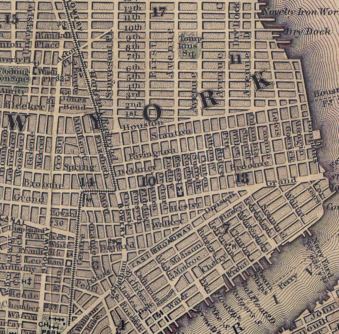
Five Points was a neighborhood area in Lower Manhattan, northeast of City Hall, at the intersection where Baxter [formerly Orange], Worth [formerly Anthony], Park Street [formerly Cross] came together to form a five point intersection. The area was made famous in the book, The Gangs of New York, by Herbert Asbury, 1928, and the screenplay to the 2002 movie. Matthew Dripps’ 1852 map, pl. 2, has the original street names, and notes the presence of the Pirnics Distillery, but not the Mission or House of Industry.
Matthew Dripps’ 1867 map of New York, pl. 5, still shows the House and Mission. G. W. Bromley’s 1879 Atlas, pl. 4 and the 1885 Robinson atlas, pl. 4, continues to show the Five Points House of Industry and the Five Points Mission, just south of The Tombs, notorious prison. The 1867, 1879 and 1885 maps all show a small underground stream in the area with a dashed line. This Five Points website has additional historical information about Five Points. The Sanborn Manhattan Landbook, pl. 8, shows the current situation with the N.Y. State Office Building and the New York County Courthouse on the old Five Points site.


No comments:
Post a Comment