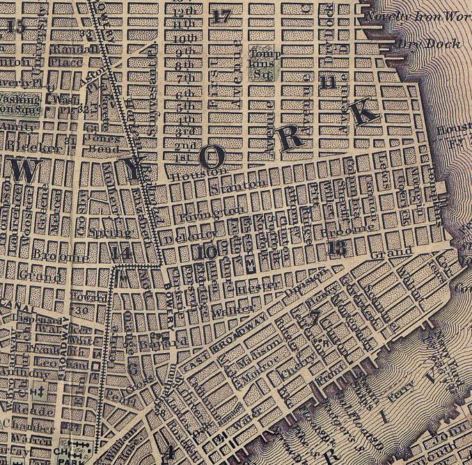
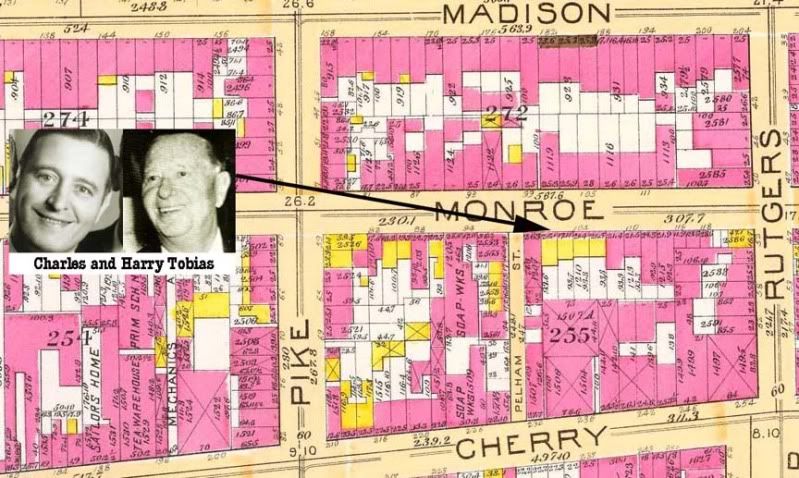
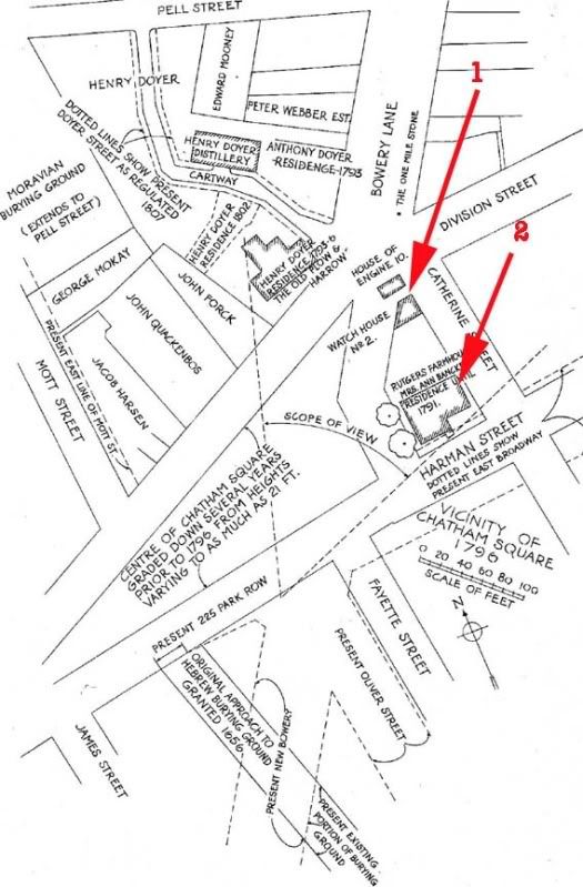
From a 1891 map. Victor lived on Madison Street marked #1. The triangular view at #2 was a good spot to see and be seen by his pals.

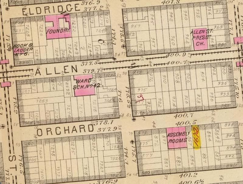
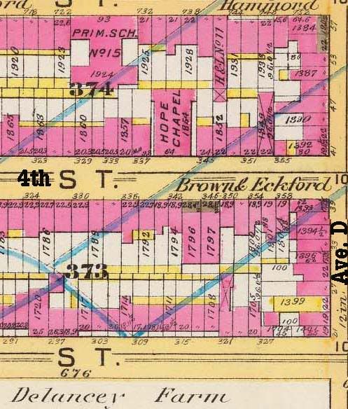
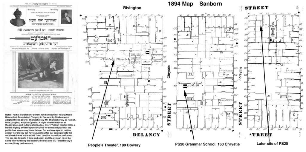 From a 1894 real estate map created by the Sanborn Fire Insurance Company. These maps were created to help fireman locate important information in order to help minimize fire loss. Those that were in color would denote different kinds of building materials. This one in particular shows where a pre-Rivington Street PS20 existed and its proximity to the People's Theater (see what's playing there-it ain't The Wedding Crasher) The entire stretch of the rectangle between Chrystie, Forsyth, Houston and Canal is now Sara Delano Roosevelt Park, constructed in the 1930's. Some notes about the YIddish theater on the bowery of that era: Yiddish theatre collection at Dorot Jewish Division NYPL By Michael Terry "The most conspicuous artistic manifestation of the Yiddish language revival was the sudden emergence and rapid triumph of Yiddish theater. Inspired by the popularity throughout central and eastern Europe of German-language companies, and their repertoires both classical and trashy, and by the elements of a Jewish theatrical tradition comprised of the ambitious Hebrew dramas of the Italian Renaissance and Baroque and the more improvised Purim plays of Ashkenaz, Yiddish theater's official birth took place in a tavern in Jassy, Romania, in October, 1876, with paternity credited to Abraham Goldfaden. Less than six years later, in the summer of 1882, the first Yiddish production in the United States was presented on the initiative of the fourteen (or, at most, sixteen)-year-old Boris Thomashefsky. The event took place at the German-American cultural and recreational center, Turn Hall, on East Fourth Street between the Bowery and Second Avenue. It was in New York that Yiddish theater blossomed, reaching the height of its appeal and influence during the last decade of the 19th century and the first decade of the 20th, when Jewish immigration was at its peak. Major venues during those years included the Roumania Opera House, on the Bowery near Grand Street, and Adler's Grand Theatre, one block east at the corner of Grand Street and Chrystie, but the scene was dominated by the Thalia and Windsor theaters, which faced off on opposite sides of the Bowery near Canal Street. The fare was made up of European classics (especially Shakespeare, often transposed to a Jewish key) as well as an array of new works, both original and adapted, including melodramas, farces, operettas, and reenactments of historical and current events. With immigration drastically curtailed and assimilation all the rage, New York Yiddish theater between the wars lacked the authenticity of its glory days before World War I. From the vulgarity of the commercial nostalgia-peddlers to the high-minded kitsch of the modernists, it was at best a silver age. In Buenos Aires, by contrast, the story was quite the reverse. Yiddish theaters had existed there since the beginning of the 20th century, but, controlled by mobsters and patronized by the city's rollicking Jewish underworld, they had taken on something of the character of the burlesque house and, accordingly, were given a wide berth by members of the respectable, Jewish community. It was not until the end of the 1920s that the genteel element, with its aspirations toward community and cultural advancement, prevailed. With encouragement from such figures on the New York scene as Thomashefsky, who would visit for the winter while their own companies were closed for the summer, a modest golden age ensued, through the 1930s and into the 1940s, that made Buenos Aires the second city of the world history of Yiddish theater."
 Another Sanborn Insurance gem. A shout out to my nephew Jamie, whose U of Buffalo attendance provided digital library access. Here's a math tech integration activity. "If there were x number of synagogues on these y square blocks, how many synagogues would there be on z square blocks?' The spot where I placed an image of the real PS 7 was an empty lot. The front of PS 7 faced Chrystie Street. The area is now part of Sara Delano Roosevelt Park. In the 1896 Tribune, the school was described as the dirtiest school in the city. Behind the Grand Theater there are "Bowling Alleys and a Turkish Bathouse. I'll try to see who was playing at the Grand Theater. The hook and ladder company on Canal Street is still a fire house 100 years later. The Boarding Stable on Allen Street logically became a parking garage. BTW, SD stands for steel door.

from old and old
Poor Charles Leupp, who died suddenly not long ago, belonged to the hide and leather merchants, whose sphere of action is called "The Swamp." Alluding upon one occasion to the great men from that locality—such as Jacob Lorillard, Abraham Bloodgood, Israel Corse, David Bryson, Gideon Lee, Peter McCartee, William Kumbel, Abraham Polhemus, Richard Cunningham, Hugh McCormick, Shepherd Knapp, Thomas Everett, Jonathan Thorne, the Brookses, James, George and Thomas, Peter Bonnett, Henry Orttery, Daniel Tooker, and other lights—the lamented Charles (who was also a great leather merchant, and had been at one time a partner and son-in-law, of Gideon Lee and Shepherd Knapp) said:
"The Roman mother, Cornelia, when asked to display her jewels, pointed to her sons. So can we, to these (leather and hide) fathers, and claim them as ours. Let us cherish their example, and emulate their noble qualities, so that hereafter our successors may, in like manner, be not ashamed of any of us, but exclaim :
"He, too, was a Swamper !"
That Swamp is a wonderful place. I can remember it well, when it was all a lot of tan vats. I have seen some of those great names above alluded to. They were great in their day and generation. But long before their time tanneries existed in the "Swamp."
A couple of hundred years ago, when people talked Dutch in the small town, they called that part of the town "Greppel Bosch," which means in English a "swamp or marsh covered with wood." The trees were cut down long ago, but the name "Swamp" is retained to this day.
The land adjoining the Swamp, extending to Pearl and Rose, including what is now called Vandewater Street, belonged in 1683 to Balthazar Bayard. A part of it afterwards in 1783—a hundred years later—was sold to the widow of Hendrick Vandewater, after whom that street was named.
I cannot tell how early the tan-yards were commenced there, but in 1744, Van Hook, Anthony & Stevens, and Becine & Rips, all had tan-yards in the "Swamp."
Jacob Street and Skinner Street existed at the time, and the other boundaries of the "Swamp" were Gold, Frankfort, Ferry, and Queen (Pearl). Frankfort only came to Skinner Street (one part changed to Cliff and the other part to Hague Street). Flack Street ran from Skinner to Queen (now Pearl). Flack is now changed to Frankfort Street.
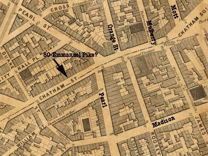
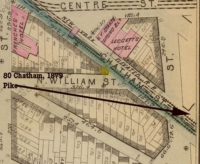
Jacob Street was named after Gov. Jacob Leisler, whose farm or estate adjoined the "Swamp," and extended as far as Chatham Street, half way from Frankfort to Pearl, on that line. It was confiscated in 1691, upon conviction of his attainder, and afterwards re-stored to him by the act of parliament, reversing his attainder. Poor Jacob was hung and buried in his own garden. The grave was about fifty feet from Chatham, near the spot where French's Hotel now stands. No houses stood nearer than Beekman Street to the spot as late as 1732. About that time his body was dug up and removed to the Dutch Reformed church burying ground in Garden (Exchange Street), where Dr. Mathews, who still lives, preached so many years (1863).
These streets were all in the "Montgomerie Ward" in 1744.
Within the recollection of many of our readers, the space bounded by Jacob, Gold, Ferry and Frankfort streets was nothing but tan-yards or vats. There were no houses. The houses on the opposite sides to the vat square were small buildings. There was not a three-story house in that vicinity. How changed now!
Among other great men of the Swamp, was Jacob Lorillard, tanner, currier and hide dealer. He died about twenty-two years ago, a man about sixty-eight or seventy years old. He had brothers who were in the tobacco business in Chatham Street, and their sons are still so. I believe there were three brothers in the tobacco business—George, Peter, and another whose name I forget. I have a faint recollection that Peter was wounded in Chatham Street, near the Hall of Records. The old debtor's jail stood there, and one night the prisoners tried to make their escape. Peter Lorillard came over from the tobacco store to assist in securing them, and was shot.
Timeline
1898 In Spring, Madison House of the Downtown Ethical Society is founded at 300 Madison Street.
1900 Under the leadership of Board Member, Bella Moses, mother of Robert Moses, Madison House embarks construction of a permanent summer camp.
1902 Hamilton House is founded on Hamilton Street. On June 17th Hamilton House is incorporated.
1910 Madison House acquires a building at 216 Madison Street.
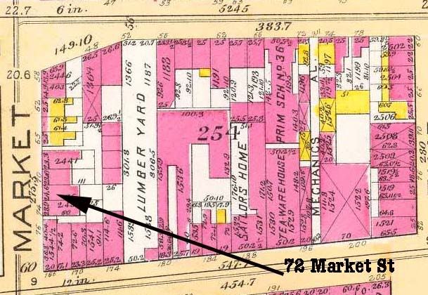
1915 In November, Hamilton House moves from Hamilton Street to 72 Market Street.
1920 In September, the summer camps are replaced by Camp Rossbach for both boys and girls at Tompkins’ Corners near Peekskill. This camp later becomes Camp Madison and later is known as Camp Madison-Felicia.
1925 In the mid-twenties, Madison House is incorporated.
1926 Dr. Algernon Black becomes Headworker at Madison House until 1930.
1929 The building at 226 Madison Street is completed
1930 During the next ten years, Madison House provides facilities for WPA workers who serve the neighborhood’s cultural, health and social needs.
1941 World War II starts. Mrs. Josiah Willard, President of Hamilton House, from 1952-1954 and Helen Greenebaum, Headworker, share the task of managing the House during the war years.
1947 The neighborhood population becomes primarily by African-Americans and Latinos. Friction between the pre-war community and the newcomers escalates. Teenage gangs present an acute problem. Geoffrey Wiener is Headworker. Helen Hall, Headworker of Henry Street Settlement and a member of the Hamilton House Board, urges Mr. Wiener on. The budget is $12,000, with a deficit carried by Henry Street Settlement House.
1950 In the 1950s the first Hamilton-Madison House Thrift Store opens on Madison Street. The thrift store moves uptown to Third Avenue and moves again on Third Avenue before locating on Second Avenue.
1951 The Golden Age Group of Chinatown is established as a group of Chinese senior citizens at Hamilton House.
1952 In February, Hamilton House offers counseling and family care work as an experimental project through an arrangement with the Family Services Division of the Community Service Society of New York
1953 When the second half of Smith Houses is completed, a community space and a 55 child pre-school Day Care Center are allocated. Hamilton House is named the sponsor. In a dedication ceremony in March 1953, Mrs. Franklin Delano Roosevelt is the principal speaker.
1954 HAMILTON HOUSE and MADISON HOUSE MERGE
1954 Mrs. Shirley Chisholm is named the Director of the Child Care Center of Hamilton-Madison House.



Have you ever been asked the question: "What is your ethnic background?" Most of us have been asked this question many times, especially by fellow genealogists. We all have the ready answers: "I'm German; I'm English; I'm Irish; and on and on.
Yet, there are about one million descendants of an ethnically distinct people who came from the Carpathian Mountain region of the former Austro-Hungarian Empire who have a confused or non-existent sense of ethnic identity. These descendants of late 19th and early 20th century immigrants know that they are of Slavic ancestry, but are unsure to which specific ethnic group they belong to. This is understandable when you examine the origins and history of the Carpatho-Rusyns.
These people came from a specific geographic area with defined ethno-linguistic boundaries in the north east region of the former Austro-Hungarian empire. This area encompassed part of the then district of Galicia , the former old Hungarian counties of; Saros, Zemplen, Szepes, Abauj, Ung, Ugosca, Bereg and Maramos. These areas are now contained within the modern day boundaries of Poland, Slovakia, Ukraine and a few villages in Romania and Hungary . These immigrants originated in a small area of a very large empire. They did not come from a specific country. Furthermore, they were members of the Greek (Byzantine) Catholic Church (also called Uniate) and the Russian Orthodox Church, both of which were totally unfamiliar to native born Americans.
Their clergy were not required to be celibate. It was indeed a difficult thing for Americans to comprehend. Even the Roman Catholic bishops in the United States, in some cases, refused to believe that Catholic priests could be married! As you might imagine, this caused many an unpleasant incident when Eastern rite Catholic priests came to America and presented themselves to the local Roman Catholic bishop as per the custom. In some cases, communications between the two sides were strained to the point that Roman Catholic bishops refused to grant faculties to the Uniate priests. These priests were often insulted and angry because they were refused permission to exercise their religious rituals which were allowed by the Holy See and defected to Orthodoxy in many cases along with their congregation. This "conversion" required no change in their religious rituals.
Confusion extended to secular life as well and it was no small wonder then that the Rusyns did not know how to respond to their American friends and neighbors to the question: "What is your ethnic identity?" Some of the immigrants responded that they were Austrian or Hungarian because they were subjects of the Austro-Hungarian Empire. Some said they were Slovaks because they came from a village that was later incorporated into Czechoslovakia. Some said they were Ukrainian. These persons of Ukrainian national orientation came primarily from the eastern reaches of Galicia, the area east of the San River, where ethnic Ukrainians were numerous and very nationalistic. This Ukrainian identity was reinforced by the clergy and was instituted by Metropolitan Josyf Sembratovych. Some countered that they were Russians because they were members of the Russian Orthodox Church. The Orthodox priests reinforced this identity. This was a very confusing situation to say the least!
The immigrants within their own ethnic communities called themselves: Rusyn, Rusnak, Ruthene, Ruthenian, Carpatho-Russian, Carpatho-Ruthenian, Carpatho-Ukrainian, and Lemko. These terms have a religious connotation signifying membership in either the Greek Catholic or Russian Orthodox Church. Some of the immigrants and their offspring called themselves "Slavish" which is a slang term that they used meaning like "Slovak" - but not really! The Rusyns have a phrase in their language in which they refer to themselves as the "Po Nashomu" People. This in effect meant to them: people like us who speak our language. This was often a response to the question "Who are you?" Such an answer leads one to the conclusion that a nationalistic identity problem did exist, and still does, for this East Slavic group of people.
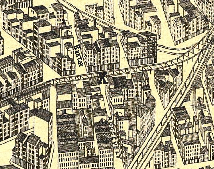

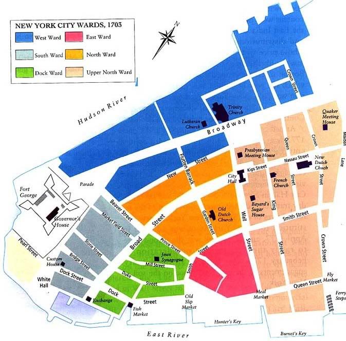 From The Historical Atlas of New York City by Eric Homberger.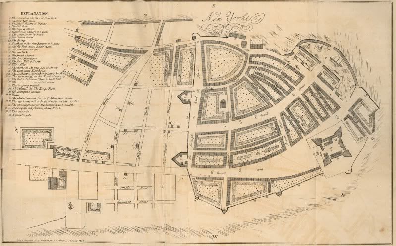


 Posts
All Comments
Posts
All Comments